
Drone Footage using Ground Penetrating Radar, Electromagnetic Locating Equipment, KMZ Mapping Tools
August 2024
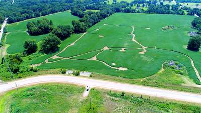
After environmental testing was completed. We were asked to obtain aerial images of the crops and the crop loss from the rigs, and traffic in the field while crops were present.
DateAugust 2024
LocationArlington, Tennessee
Tags
Ground Penetrating Radar, Electromagnetic Locating Equipment, KMZ Mapping Tools, Drone Footage


Drone Footage using Ground Penetrating Radar, Electromagnetic Locating Equipment, KMZ Mapping Tools

After environmental testing was completed. We were asked to obtain aerial images of the crops and the crop loss from the rigs, and traffic in the field while crops were present.